The Segments and Extents window shows detailed information about segments and extents, both in tabular and graphical form. Use this window to quickly locate the biggest or smallest segments and get an idea about the location of the extents in the datafiles. Lab128 keeps a snapshot of dba_extents internally and this snapshot is used it in this window. For Oracle 9+, segment statistics from v$segstat are available as well.
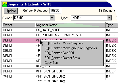
The Segments and Extents window is a convenient place to initiate a move of segments or do other actions in the context of the selected segment. This can be done using pop-up menus and calling SQL Central.
There are two large areas in this window: the upper area is a list of selected segments; the lower one - a list of datafiles showing the extent map. Because each segment belongs to only one datafile, the relationship between these two areas is many-to-one: a list of selected segments defines the corresponding list of datafiles and extent maps.
The segments can be selected / filtered by the Owner, Segment type, and Tablespace properties using the corresponding boxes in the upper part of the window. An "ALL" or empty value in the boxes causes all segments to be shown. As the list of selected segments narrows down to the area of interest, only the datafiles of the selected segments are shown. Each extent is framed in the extent map. The extents of listed segments are shown in cyan color with blue frame.
Note. Because the size of some extents is small or the datafile size is large, the extent frames may merge, forming continuous areas of blue.
Areas of the datafile not occupied by any extent are colored in light yellow. If the datafiles contain extents that have been filtered out by the criteria, then these extents are shown in light green.
In the list of selected segments, one segment is highlighted with the pink selection bar. The extents map for that particular segment is highlighted in pink. A small "V" mark indicates the location of the initial extent. When choosing another segment, the extent map updates automatically.
Moving the mouse over the extent map causes the name of the corresponding segment to be displayed in the bottom status panel. Clicking on an extent changes the highlighted segment in the segment list.
The area right above the extent map presents a color legend and contains summary data about the corresponding space data in the datafile.
For Oracle 9 or higher, there is a check box in the upper right corner that enables Segment Statistics columns in the segment list. The number of columns corresponds to the number of Oracle-maintained statistics (listed in v$segstat_name).
Right-click on the list of segments to open a pop-up menu. The pop-up menu is shown in this picture:
